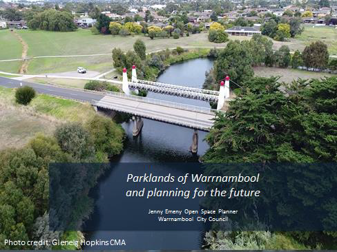
•Traditional Owner Acknowledgement
•Rotarians tree planting around city
•Role as open space planner in strategic planning area of council
-What do we mean by open space? Basically our public parks, gardens, sports fields, trails and nature reserves. There are many people that do work relating to our open spaces at council. My role deals mostly at the higher planning level so I am not involved in the day to day activities within our parks but more the long term strategic direction.
-Last year myself and other council staff met with Michael Boyd to talk about your interest in EJ King park and where it sits in Councils planning and priorities.
-Tonight I thought I’d talk about the big picture of open spaces and their value to Warrnambool, our open space strategy for Warrnambool and some of the achievements from that, our current open space planning project on the Merri River, and then the Hopkins River and EJ King Park, and where it sits in our planning framework.
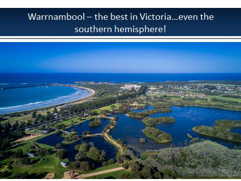
I’m not sure if you have all heard this before, but Warrnambool has recently been identified as the most liveable city in Victoria by two separate assessments, the Deolite and Ipsos indexes of livability.
And one of the major contributors to our great liveability in Warrnambool are our open space areas around the foreshore and Lake Pertobe.
I recently read some new research that if you spend two or more hours in nature per week there are measureable benefits to your health and wellbeing.
But it has to be at least 2 hrs across the week to receive a measured benefit. So spending time in these areas is good for your mental and physical health.
I don’t know about everyone else, but when I see this view of Warrnambool, I know I always think how lucky am I to live here.
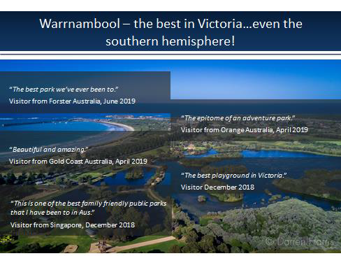
And the world agrees. In 2014 Lake Pertobe was listed as one of the top 10 parks in the south pacific region on the TripAdvisor website, which is based on visitor feedback.
Lake Pertobe consistent gets good reviews on the website, and has maintained a 5 star rating for several years. These are a few recent comments from visitors from around Australia and even overseas.
So I think we are punching above our weight here in Warrnambool, and I think it is something for us to be proud of.
And much of what we enjoy now came from the early vision for Lake Pertobe by a City Engineer called Ed Johnson back in the 1970s.
This statement here is a more recent vision for Warrnambool, which came directly from the Warrnambool Community.
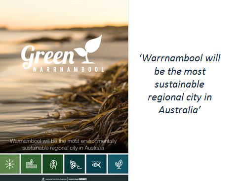
At the end of last year Council adopted a Green Warrnambool Plan. It aspires to Warrnambool being the most sustainable regional city in Australia by 2040.
So we are still reaching. We are an aspirational lot here in Warrnambool.
It is obviously a very ambitious goal, but our sustainability team at council are already taking significant steps towards this goal.
I believe our open spaces also have a big role to play in achieving this long term goal, through supporting walking and cycling for transport, and restoring our natural environment.
So I’m going to test your local open space knowledge for the next few slides and see if you can identify where some of these photos have been taken.
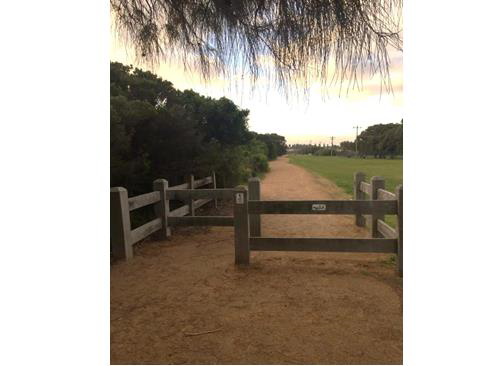
Port Fairy to Wbool rail trail along the Merri near Pertobe Road.
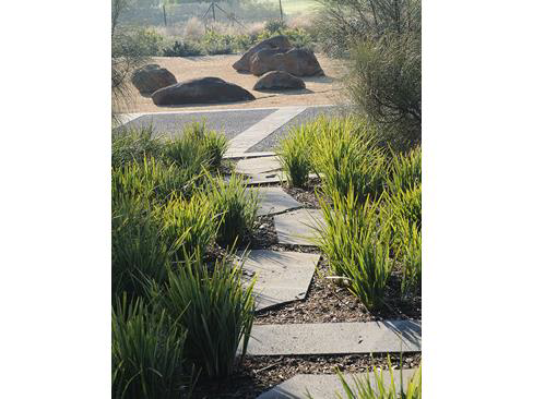
Japanese friendship garden off Grafton Rd.
For me this is the best playground in Warrnambool outside of Lake Pertobe and one of the nicest parklands.
Jubilee Park Woodford or Wurrumbit Birrng Yaar (which means ‘long waterhole’ in the traditional Peek Whurrong language).
If you haven’t been out there for a few years, it is worth going back for a look.
Pedestrian bridge to Jellie Reserve walking track on other side of river in Woodford.
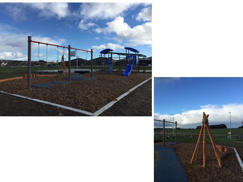
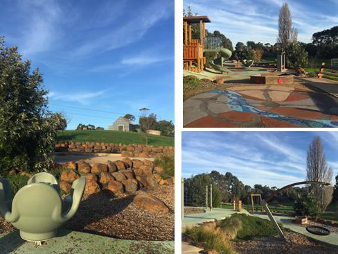
Our 63rd and newest playground in Warrnambool, at the corner of White and Aberline Roads.
Playgrounds are actually very expensive to replace and maintain nowadays. So this is a challenge for council as costs rise.
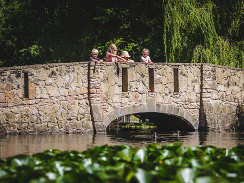
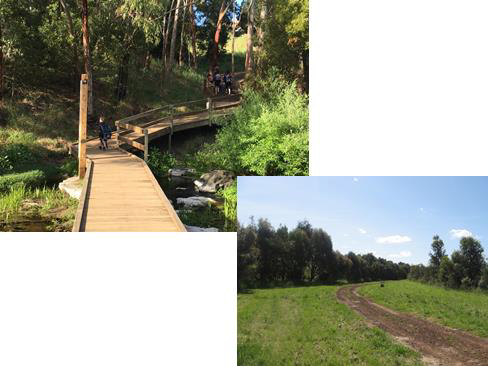
Botanic gardens and the historic bridge which is part of the state heritage listing of the gardens.
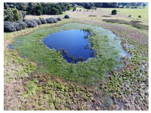
Maam wetland reserve off spring flat road in east Warrnambool.
A fauna survey was recently done here. One was a colony of tiny white footed dunnart, which are a small native mammal.
So we have a fantastic and diverse network of open spaces and parklands in Warrnambool, the ones I have shown are just a small sample.
Can any one take a guess how many individual parks and open spaces we have in Warrnambool? It is 209.
When compared to other Victorian councils, we benchmark fairly well for our population size.
But this is something we need to continue to plan for and manage in order to maintain our liveable status, support tourism and recreation, and reach our ambitious sustainability goals.
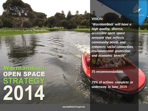
To help manage and plan for the future of our open space network, in 2014 Council adopted the Warrnambool Open Space Strategy. At that time we did a community consultation and heard that open spaces are really important to Warrnambool residents.
The biggest issues related to improving access to and connections between parks.
A common criticism of any government agency is we like writing plans but do we implement them?
In 2014 we adopted 75 recommendations. As of this month, of the 75 recommendations, 79% are either completed or underway.
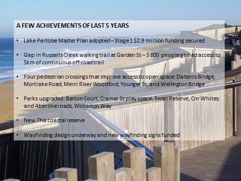
These are just a few of the highlights from the past 5 years.
•We’ve adopted a new Master Plan for Lake Pertobe, and you may have heard that we received federal funding to implement the first stage, which is $2.9 million worth of works. So you may ask why we need to put more money in to Lake Pertobe when it is already good. Yes it is already good and we don’t want to change it too much, but it is part of our premier open space precinct in Warrnambool. It is important in terms of our lifestyle, tourism, events, and our natural environment.
•It has massive flow-on benefits to the City, so we need to make sure it stays this way by continuing to invest in it. So that is LP.
•We’ve also completed the Russell’s Creek trail at Garden street. This has resulted in nearly 4000 people gaining access to a continuous 5km of off-road trails
•We’ve also added pedestrian connections at a number of locations where there was a barrier to accesssing open space, whether it be a river, or busy road. In many parts of Warrnambool, it wasn’t that tehre weren’t enough parklands, but that people could get to them. So we've added pedestrian crossings at Dalton’s Bridge, Wellington Bridge, Younger St over the Merri, the Mortlake Rd/ Wollaston Rd intersection, and over the Merri at Jubilee Park in Woodford
•We’ve upgraded a number of parks in that time. Barton Court park in west Warrnambool has been upgraded to a neighbourhood park using developer funds – this improved open space access to over 300 properties, plus more as development occurs.
•We have also been planning for a number of open spaces in areas to be developed, including a new 7ha coastal reserve east of Logan’s Beach as development occurs out that way.
•We have some design work underway for wayfinding signs and some signs already funded to go in at Lake Pertobe and the Foreshore. Wayfinding signs are..
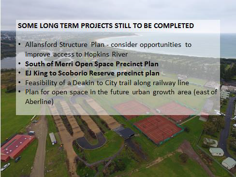
There are still a few projects from the strategy yet to be completed. These are a few of them, I won’t read them all out as I want to focus on two.
-The South of Merri Open Space Precinct Plan, which is a currently funded project in the strategic planning team.
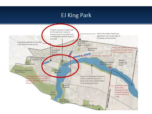
-And the EJ King to Scoborio Reserve precinct plan as I know this is of interest to the group.
-The South of Merri Open Space Precinct Plan, which is a currently funded project in the strategic planning team.
-And the EJ King to Scoborio Reserve precinct plan as I know this is of interest to the group.
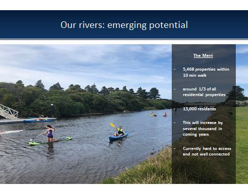
So we all know the foreshore and Lake Pertobe are great, but we also have this emerging potential in our two rivers – the Hopkins and the Merri.
[Just on the weekend, I popped in to watch part of the Bream Classic held on the Hopkins with Merv Hughs attending, and all of the expensive boats brought to town. And I thought, what a great thing to bring to Warrnambool for our economy.]
I think as we grow, the rivers are going to become more important as recreation corridors than they have been previously.
Our rivers are closer to where most people live in Warrnambool compared to the foreshore. There are currently nearly 5,500 properties within a 10 min walk of the Merri.
This is around 1/3 of residential properties or 13000 residents, and this will continue to grow by several thousand as Warrnambool grows.
The problem is, at the moment, there are limited opportunities to access the river for recreation purposes and our riverside parklands are not well connected.
But there is a growing interest in the two rivers, particularly the Merri. The state government though the Glenelg Hopkins CMA currently sees it as a priority, and last year a Merri Alliance made up of 9 groups and agencies was formed.
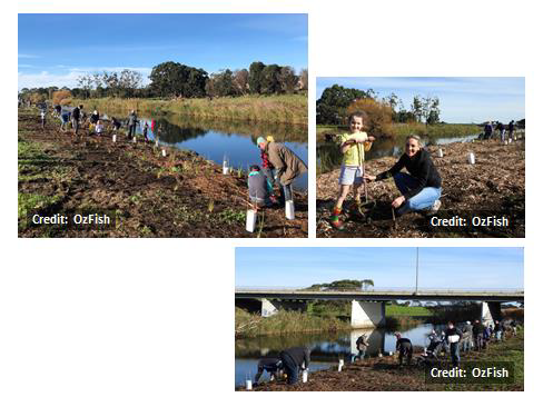
I’m also aware that the local Rotary groups have been active in revegetation works along the Merri recently.
This is the tree planting at Cassidy’s bridge I mentioned at the start of the presentation run by OzFish and the Glenelg Hopkins CMA, where I met a number of Rotarians on the day.
This area is to become public open space, so the trees planted will become part of a new trail and open space corridor for Warrnambool as development occurs along here.
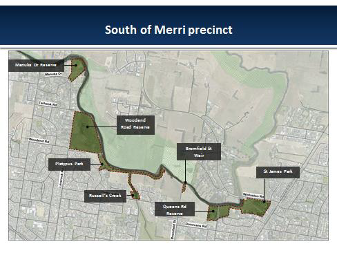
So our current priority project in open space planning is an open space precinct plan along a stretch of the south side of the Merri River.
The precinct includes Manuka Dr Reserve, public land at the end of Woodend and Tarhood roads, Platypus Park, Bromfield St Weir, Queens Rd Reserve and St James Park.
The purpose of the precinct plan is to look at how we can better connect and activate this space as a whole for people to better access the river.
So the parks in the precinct don’t make up a huge part of Warrnambool’s open space network in terms of area, but strategically they are really important.
It is probably the best opportunity for the most current residents to access the Merri river.
It provides the opportunity to improve equity of access to open space in west Warrnambool. West Warrnambool has our highest population, but the poorest access to open space and off road trails. It also has pockets of disadvantage.
There is also a large open space corridor planned for the north side of the river, which will open up access to the river. When this happens people are going to want to access both sides of the river and now is the time to plan for that.
.png)
The precinct also represents the last piece in the puzzle to connect the current Russell’s Creek walking trail that ends at Daltons Road with a future north of Merri walking trail. If we connect the trails at this point, it has the potential to connect over 25km of current and future trails in warrnambool.
This shows where walking trails and pedestrian crossing points are in the North of Merri Structure Plan, and where Russells Creek trail currently ends.
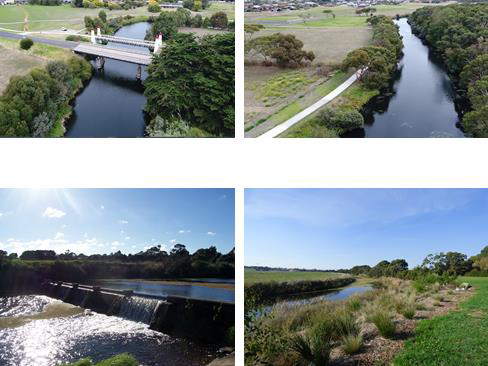
So these are some of the parklands in the precinct.
We are about to commence a public consultation on this precinct to look at what the issues and opportunities are. It is mostly floodprone, so there are some limitations, but there are also good opportunities to improve access along and to the river.
It would be fantastic to get your feedback for this project.
We are about to commence the public consultation in the next few weeks, which includes a survey. They are going out the next week, so I encourage you to look out for it.
Or, I have brought in a few surveys if anyone wanted to fill one out early and give it to me tonight, particularly if you live near the area. The only disadvantage if you fill it out tonight is that you don’t get the issues and opportunities paper that will go out with the online survey.
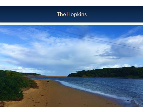
So we are focusing on the Merri parklands at moment, but the Hopkins is also a major asset in the Warrnambool open space network.
It has very high cultural significance for the people of the Maar nation.
It is a premier fishing river for Victoria.
The Hopkins is a long term focus of the GHCMA, and the lower Hopkins estuary a priority estuary.
It also has growing tourism value, especially with the recent research done at Moyjil that proposes that humans have been here longer than any other place in Australia.
When we did the open space strategy in 2014, we looked at different planning precincts in Warrnambool. We looked at the current and future population of the precinct, and access to open space.
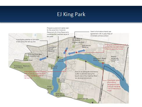
This one is the south hopkins precinct. It has some amazing parklands including parts of the foreshore, Moyil, Logans beach and of course EJ King. However it has some of the worst accessibility to open space due to barriers such as the railway line and river, and a lack of footpaths in some areas.
-Compared to Merri, the opportunities to access the Hopkins are more limited in the short term.
-When I was doing the open space strategy, what stood out to me was how important the EJ King to Scoborio reserve precinct was.
-When I was doing the open space strategy, what stood out to me was how important the EJ King to Scoborio reserve precinct was.
-For me, doing long term planning for the EJ King to Scoborio precinct.
And this is why the precinct that includes EJ king park is so valuable to Warrnambool. It is these views, and this access to the river.
So the recommendation in the OSS is to do a precinct plan similar to the one we are doing on the Merri at the moment.
We don’t have a nominated time frame for the EJ King to Scoborio plan. It isn’t necessarily urgent, but it is very important strategically. So we want to do it at the right time.
We’ve just got a new Chief, and we already have a number of recent plans that need to be funded, so that may influence when we do it.
But rest assured, any work you are doing at EJ King will one day be part of a significant long term asset to Warrnambool.
I hope the message I’ve gotten across is that our open spaces are a bit asset to Warrnambool, and play a major role in our lifestyle, economy and the protection of our local environment.
Whilst we all recognise the value of the coast, our waterways are going to become more important.
Our current focus in City Strategy at present is on the south of Merri Precinct, which will play an important role
We certainly do recognise the strategic value of the EJ King site, and I think you should keep that conversation going with council.
It is great the work you are doing there already.
I’m sorry I can’t give a timeframe on when that might happen. It definitely won’t be before we finish and maybe even fund the South of Merri plan.
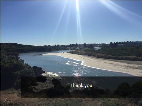
Thank you.